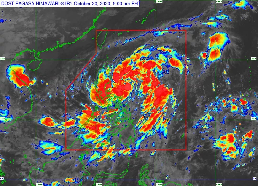
-TROPICAL DEPRESSION “PEPITO” SLIGHTLY ACCELERATES WEST-NORTHWESTWARD TOWARDS NORTHERN-CENTRAL LUZON AREA.

In its 5AM severe weather bulletin today, PAG-ASA said that tropical depression Pepito may reach tropical storm category before making landfall. However, there remains a possibility that this tropical cyclone makes landfall as a tropical depression.
It forecasts that after crossing the landmass of Luzon, Pepito is forecast to intensify and may reach severe tropical storm category by Thursday.
The tropical depression is currently moving west-northwestward towards the Northern-Central Luzon area with a maximum sustained winds of 55 km/h near the center and gustiness of up to 70 km/h.
It forecasts to make landfall over the coast of Aurora-Isabela area tonight, cross the Luzon landmass, and emerge over the West Philippine Sea tomorrow morning.
Today it will bring moderate to heavy rains over Bicol Region, Marinduque, Romblon, Quezon, Aurora, Nueva Ecija, Nueva Vizcaya, Quirino, Isabela, mainland Cagayan, Pangasinan, and Benguet. Light to moderate with at times heavy rains will be experienced over Metro Manila, Cordillera Administrative Region, MIMAROPA, Western Visayas, Zamboanga Peninsula, Bangsamoro, Northern Mindanao, and the rest of Ilocos Region, Cagayan Valley, Central Luzon, CALABARZON, and MIMAROPA.
Flooding (including flashfloods) and rain-induced landslides may occur during heavy or prolonged rainfall especially in areas that are highly or very highly susceptible to these hazards. PAGASA Regional Services Divisions may issue local thunderstorm/rainfall advisories and heavy rainfall warnings as appropriate.
High winds (strong to near gale) will be experienced in areas under Tropical Cyclone Wind Signal (TCWS) #1. High winds to gale-force winds with occasional gusts due to the northeasterly surface wind flow will be experienced over Batanes, Babuyan Islands, and the coastal and/or mountainous areas of mainland Cagayan, Apayao, and Ilocos Norte.
Hazards affecting coastal waters:
• Gale Warning is in effect over the seaboards of Batanes, Cagayan, Isabela, Ilocos Norte and Ilocos Sur due to rough to very rough seas (2.8 to 5.0 m).
Moreover, the seaboards of areas under TCWS #1 will also experience rough to very rough seas (2.5 to 4.5 m). Sea travel is risky over these areas, especially for those using small seacrafts.
Moderate to rough seas (1.5 to 3.0 m) will prevail over the western and eastern seaboards of Southern Luzon and the eastern seaboards of Eastern Visayas, Caraga, and Davao Region. Those with small seacrafts are advised to take precautionary measures when venturing out to sea. Inexperienced mariners should avoid navigating in these conditions.
TROPICAL CYCLONE WIND SIGNAL
• TCWS #1
(30-60 km/h winds prevailing or expected in 36 hours)
LUZON:
Isabela, Quirino, Nueva Vizcaya, Abra, Kalinga, Mountain Province, Ifugao, Benguet, Ilocos Sur, La Union, Pangasinan, Aurora, Nueva Ecija, Tarlac, Zambales, Bulacan, Pampanga, Bataan, Metro Manila, Rizal, the northern portion of Quezon (General Nakar, Infanta, Real) including Polillo Islands, the extreme northern portion of Camarines Norte (Vinzons), and Catanduanes
The public and the disaster risk reduction and management council concerned are advised to take appropriate actions and watch for the next Severe Weather Bulletin to be issued at 8 AM today.


