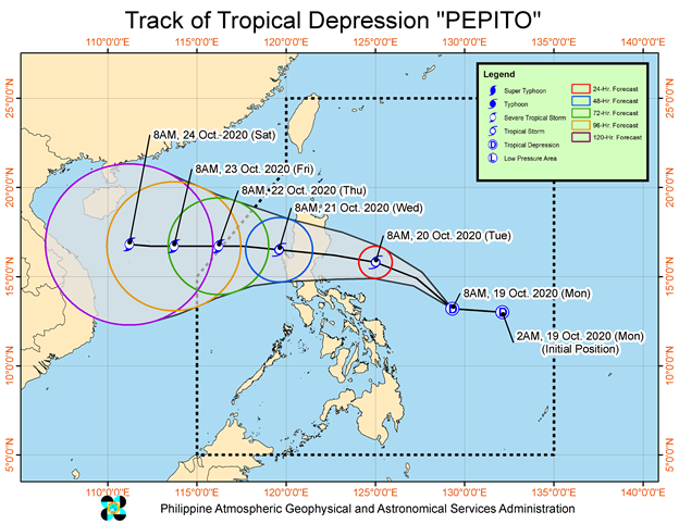
–THE LOW PRESSURE AREA EAST OF CATANDUANES HAS DEVELOPED INTO TROPICAL DEPRESSION
-TROPICAL DEPRESSION “PEPITO” ACCELERATES WESTWARD WHILE MAINTAINING ITS STRENGTH

In its 11AM Weather Advisory, the state-weather, PAGASA, said Pepito will move west northwestward or northwestward today, then turn westward tomorrow towards the Northern Luzon-Central Luzon area. On the forecast track, the tropical cyclone is forecast to make landfall over the eastern coast of Northern Luzon-Central Luzon area between tomorrow evening and Wednesday early morning. It may emerge over the West Philippine Sea on Wednesday morning.
It is forecast to intensify into a tropical storm before it makes landfall. After crossing the landmass of Luzon, “PEPITO” may further intensify over the West Philippine Sea and may reach severe tropical storm category by Thursday.
Areas under Tropical Cyclone Wind Signal (TCWS) #1 may experience occasional gusts in the next 36 hours. Based on available meteorological data, TCWS#1 may be raised over the eastern portion of Quirino and other municipalities in Isabela and Aurora in the next bulletin
The northeasterly surface windflow partly enhanced by “PEPITO” may bring strong-force to near gale-force winds with occasional gusts over Batanes, Babuyan Islands, and the coastal and mountainous areas of northern Ilocos Norte, Apayao, Cagayan, Isabela, Aurora, Quezon, Camarines Norte, Camarines Sur, Albay, Sorsogon, and Northern Samar
Gale Warning is in effect over the seaboards of Batanes, Cagayan, Ilocos Norte, Ilocos Sur, and Isabela due to rough to very rough seas (2.8 to 4.5 m) caused by the northeasterly surface windflow. Sea travel is risky over these areas, especially for those using small seacrafts.
Moderate to rough seas (1.5 to 3.0 m) due to “PEPITO” and the northeasterly surface windflow will be experienced in the next 24 hours over the eastern seaboards of Central Luzon and Bicol Region and the seaboards of Northern Samar and Eastern Samar. Those with small seacrafts are advised to take precautionary measures while venturing out to sea.


