The Philippine seismologists have issued an urgent warning to communities surrounding Kanlaon Volcano regarding the potential for life-threatening lahars and sediment-laden streamflows as Tropical Cyclone “Verbena” and a shear line bring heavy to intense rainfall across the Central Philippines.
According to the advisory issued at 11:00 AM today, November 24, 2025, by the Department of Science and Technology – Philippine Institute of Volcanology and Seismology (DOST-PHIVOLCS), the prolonged downpour forecast by weather department poses a significant danger to Negros Island.
With Kanlaon Volcano currently at Alert Level 2, officials are urging heightened vigilance and immediate readiness for residents in pre-determined danger zones.
The risk of lahars is compounded by recent volcanic and weather events. PHIVOLCS explains that intense rainfall can erode loose volcanic material, specifically the remnant pyroclastic density current (PDC) deposits and loose ashfall from the explosive eruption on October 24, 2025, as well as debris from recent ash emissions.
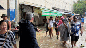
Furthermore, non-eruption lahars may occur where the upper slopes were weakened or exposed by landslides during the passage of Typhoon Tino earlier this month. This instability could cause soil failure, feeding debris into river systems that have already delivered destructive flows to downstream areas in recent weeks.
Several localities have been identified as being at risk for these hazards. Communities in Negros Occidental—specifically Bago City, La Carlota City, La Castellana, Moises Padilla, and San Carlos City—as well as Canlaon City in Negros Oriental, are situated along major channels draining the southern, western, and eastern slopes of the volcano. PHIVOLCS has warned that these areas may face lahars, muddy run-off, and related flooding or siltation. The agency explicitly listed the following waterways as critical danger zones: the Ibid, Cotcot, Talaptapan, Malaiba, Buhangin-Indurayan, Najalin, Inyawan, Maragandang, Intiguiwan, Camansi, Maao, Tokon-tokon, Masulog, Binalbagan, and Linothangan Rivers, as well as the Panubigan, Panun-an, and Taco Creeks.
Authorities emphasized that these flows are physically dangerous and capable of causing severe destruction.
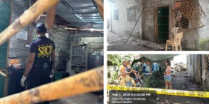
Observations from Typhoon Tino demonstrated that Kanlaon lahars are strong enough to transport enormous volumes of gravel and boulders, threatening communities with impact force, inundation, burial, and washout.
PHIVOLCS strongly advises local government units and residents in these risk areas to continually monitor rainfall conditions and take pre-emptive response measures. Residents, including those in communities further downstream of the identified channels, are advised to avoid traversing affected streams and to be fully prepared for evacuation should the situation deteriorate.